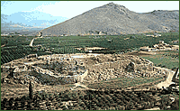
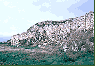
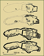
The Mycenaean citadel of Tiryns is built on a rocky hill of 18 metres high in the plain of the Argolis gulf. The hill is located at 1,5 km from the coast but as revealed by geological research, during the Mycenaean period, the sea reached the foot of the hill. The earliest settlement on the hill of Tiryns dates to the Neolithic Age. Settlement during the Mycenaean period was developed on the three elevations of the hill which are defined as Upper, Central and Lower citadel which occupy 20.000 square metres. The Mycenaean fortification wall, built with Cyclopean masonry, is older than that of Mycenae and is the most imposing of all the Mycenaean citadels. The oldest part was built in roughly 1400 BC. Later, the arrangement of the eastern entrance changed, the south wall was fortified at a greater degree, the eastern entrance became almost impregnable and the fortification wall of the Lower Citadel was constructed. Now the fortification included the whole surface of the hill ensuring in this way the water supply of the whole citadel. A wide ramp led to the principle propylon of the Upper Citadel while a second one led to the Lower Citadel. The ramp ended in an open colonnaded court. Under this court are the corbel-vaulted galleries which communicate with a series of square corbel-vaulted magazines. The grandiose propylon was composed of two stoas with facades that had columns and jambs on the side walls. The propylon led to the external plastered court of the palace. The north side of the court was defined by two rooms which are characterized as guard-posts or rooms of the palace archive and of a second propylon which led to a square plastered court. On the north side of the court stood the magnificent palatial complex of the 13th century, the palace of the wanax with his two megara which were decorated with frescoes and painted floors and which included the throne rooms. The so-called "Central Citadel" was inhabited during its period of prosperity but it has not been researched extensively. At the western wall of the Central Citadel, the "western outpost", a semicircular supplementary wall was built. In its internal side was a stone ____ ____ staircase which served probably as an embrasure. At this part of the citadel a ceramic hearth was discovered. On a large part of the wall of the "Lower Citadel" were four-sided niches with ____ ____ and narrow embrasures which were used as storerooms and houses. The main access to the Upper Citadel was achieved by a narrow passage of the eastern side via the ramp. The wall had also two supplementary arched gateways. Two arched openings to the external part of the citadel led to long underground galleries which were used as cisterns. During the 13th century BC residences, workshops, an altar and a small shrine were built in this place in terraces and with a common planning. The buildings of the Tirynthian citadel were destroyed by earthquake just before 1200 BC. During the last Mycenaean years the settlement which was now unfortified extended to the coast occupying a quarter of a square kilometre. After 1125 BC roughly, the buildings of the Tirynthian citadel, as those of Mycenae were little by little abandoned. The building activity of the inhabitants of Tiryns were not limited to the citadel. During the period of prosperity, dykes and walls were built in the plain to divert the riverbed of the nearby river and to protect in this way the region from flooding. To the east of the citadel, Mycenaean chamber tombs have been discovered while at one kilometre from the citadel, at the foot of Prophitis Ilias, a tholos tomb was found. |
 |
|
|
Tiryns. Aerial view
of the citadel.
|
||
 |
||
|
Tiryns. View of the Cyclopean wall.
|
||
 |
||
|
Tiryns. Plans of the successive phases
of the citadel. |
||